What was life in America like a century or more ago? We can read about it, of course, in books and articles written at the time as well as in the works of historians of the period. But fortunately, we can also see the America of the 19th century with our own eyes — at least the latter 60 years or so of it.
The earliest techniques of photography reached our shores around 1840, and various archives, both public and private (including Getty Images, from whom the photographs here are sourced) have ample collections of the results. Visual reportage is available, then, if you want to know (for instance) what a hospital looked like 100 years ago.
The photographers of the 19th century would have gaped disbelievingly at the idea that a small rectangular object could instantly capture an image from life — one that could be reproduced immediately, in excellent quality, on paper or a screen. Suffice to say, photography wasn’t like that in the old days.
The earliest cameras were huge, cumbersome objects that required exposures lasting many minutes if not longer. The French artist Louis Daguerre introduced the world to the first (vaguely) viable photographic process in 1839, and some of the earlier images in this collection are so-called daguerreotypes. The first film as such, in something approximating the form we know it in, appeared only in 1885.
Whatever the technical challenges of taking photographs may have been, many men (and a few women) persisted, leaving us evocative imagery of the Civil War, homesteaders on the Great Plains, the beginnings of towns and cities, unspoiled landscapes, and more. (These are the most beautiful natural wonders in every state.)
24/7 Tempo has assembled a portfolio of 50 photos documenting various aspects of the American scene between 1840 and 1900. Note that many of the dates are approximate, but in many cases are estimated according to evidence revealed in the images themselves.
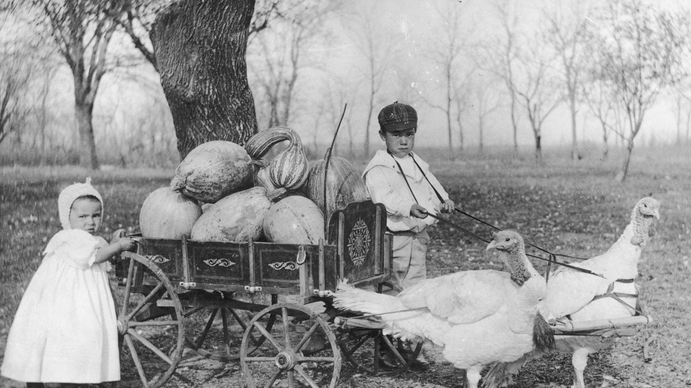
1840: Children with a turkey cart
Fanciful portraits of children were popular in the 19th century. This one shows a young boy and girl with a cart full of pumpkins and gourds “pulled” by a couple of turkeys, who almost certainly wouldn’t have remained in harness for long. The source for this image dates it from about 1840. If that’s correct, it would be a very early example of such portraits, as commercial photography (in the form of daguerreotypes) was introduced to the world only in 1839.
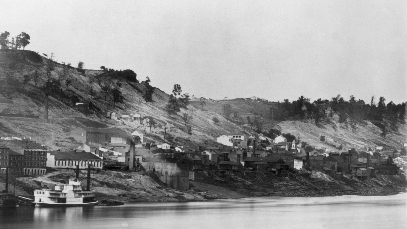
1848: Steamboat on the Cincinnati waterfront
Growing out of a settlement founded in 1788, Cincinnati was the first major American city established after the Revolutionary War. It was a boomtown during much of the 19th century, thriving after the introduction of steamboats on the Ohio River in 1811, with pork and hay as its major exports. The shift from steamboats to railroads as the principal means of moving freight in the late 19th century slowed the city’s economic growth.
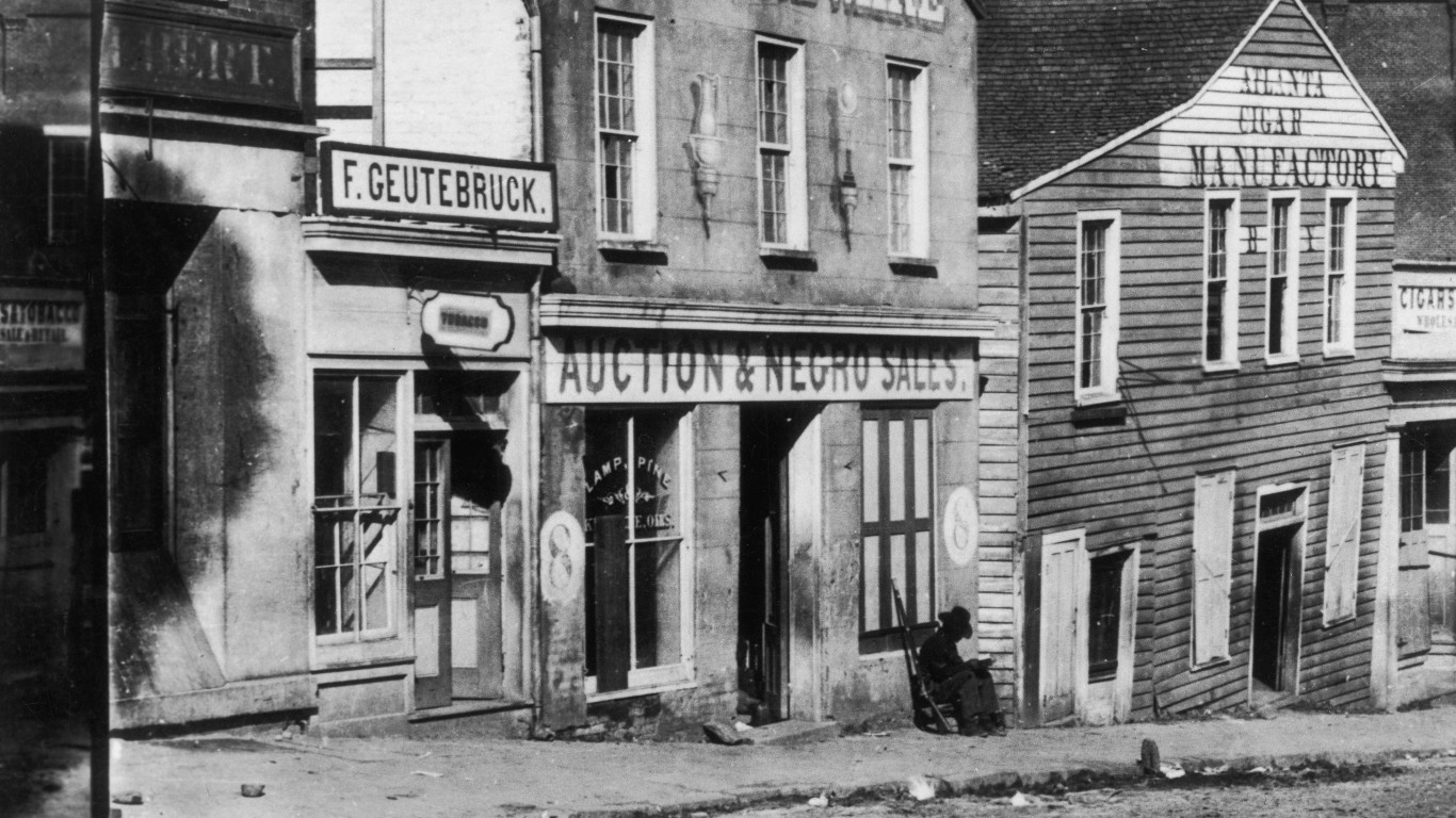
1850: A slave market in Atlanta
This store on Atlanta’s Whitehall Street, seen in the pre-Civil War years, doubled as a slave market. The man with the rifle sitting outside to the right of the entrance was presumably a guard. The photographer was George Norman Barnard, who later became the official army photographer for Gen. William Tecumseh Sherman’s Military Division of the Mississippi.
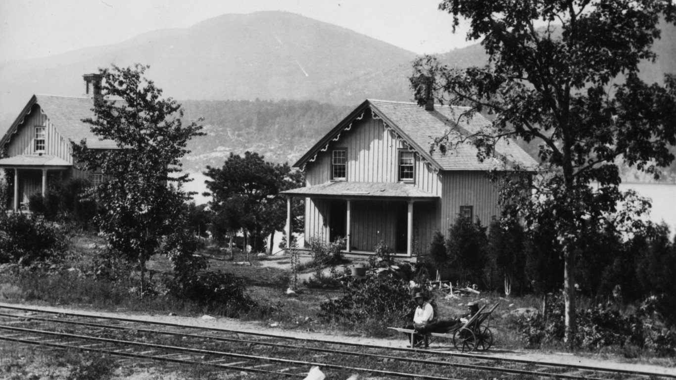
1859: Cottages on the Hudson River
This photograph of cottages between the railroad tracks and the Hudson River, at West Point, New York, was originally part of a stereoscopic image taken by a noted Victorian-era English photographer, William England. The shots he took on a tour of America and Canada in 1859 were among the first photographic views European audiences had of North America.
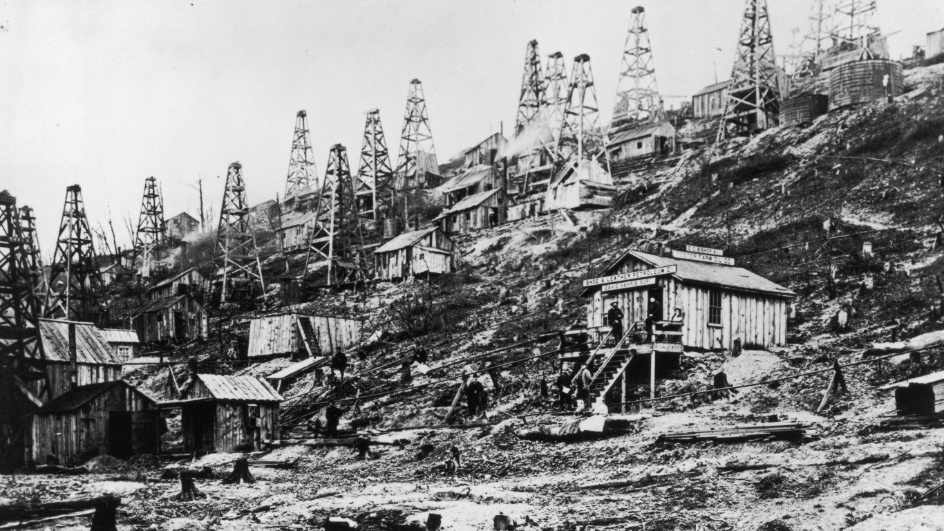
1859: America’s first oil field, Titusville, Pennsylvania
The first oil well in the U.S. was drilled by a New York businessman named Colonel Edwin Drake in 1859 at the confluence of Oil Creek and Pioneer Run, southeast of Erie. By the mid-1860s, dozens of additional wells had appeared on the site. A local photographer, John Mather, documented the scene with this and other photographs. Note the signage for the curiously named The Shoe & Leather Petroleum Company.
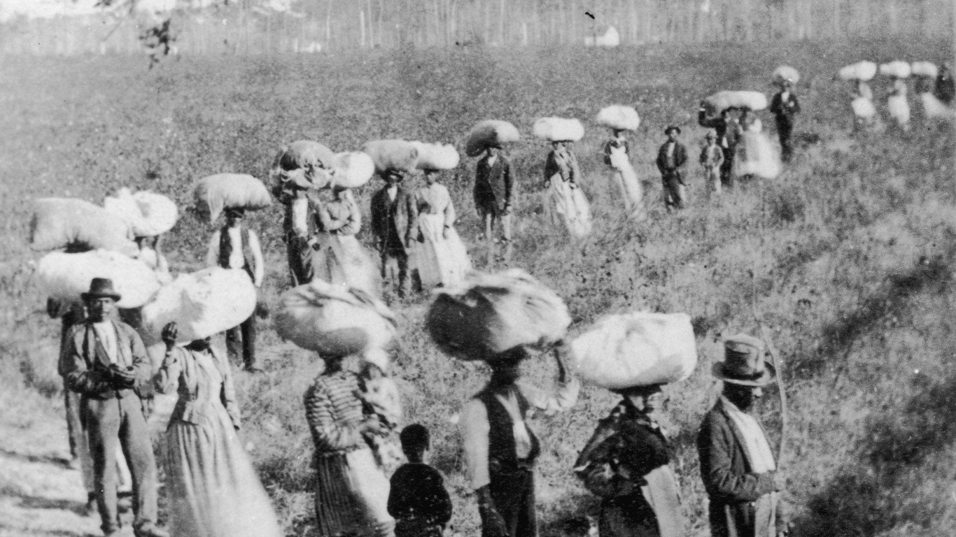
1860: Slaves carrying cotton
This picture of slaves returning from the cotton fields somewhere in South Carolina, probably shortly before the Civil War, was taken by the noted photographer George Norman Barnard. The state had a larger number of slaves per capita than most other states at the time, though the majority of them worked harvesting rice, not picking cotton.
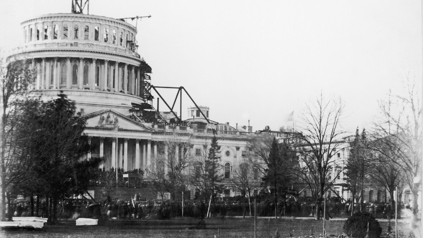
1861: The U.S. Capitol dome under construction
The first dome on the U.S. Capitol building, made of copper-covered wood, was completed in 1823. After the building was expanded in the 1850s, it was deemed unpleasant to look at and a project to replace it began in 1855, continuing for 11 years. The second dome, still in place today, is cast iron, painted to resemble the stone façade of the building it surmounts. This photo was taken on Mar. 4, 1861, the day Abraham Lincoln was inaugurated for his first term as president.
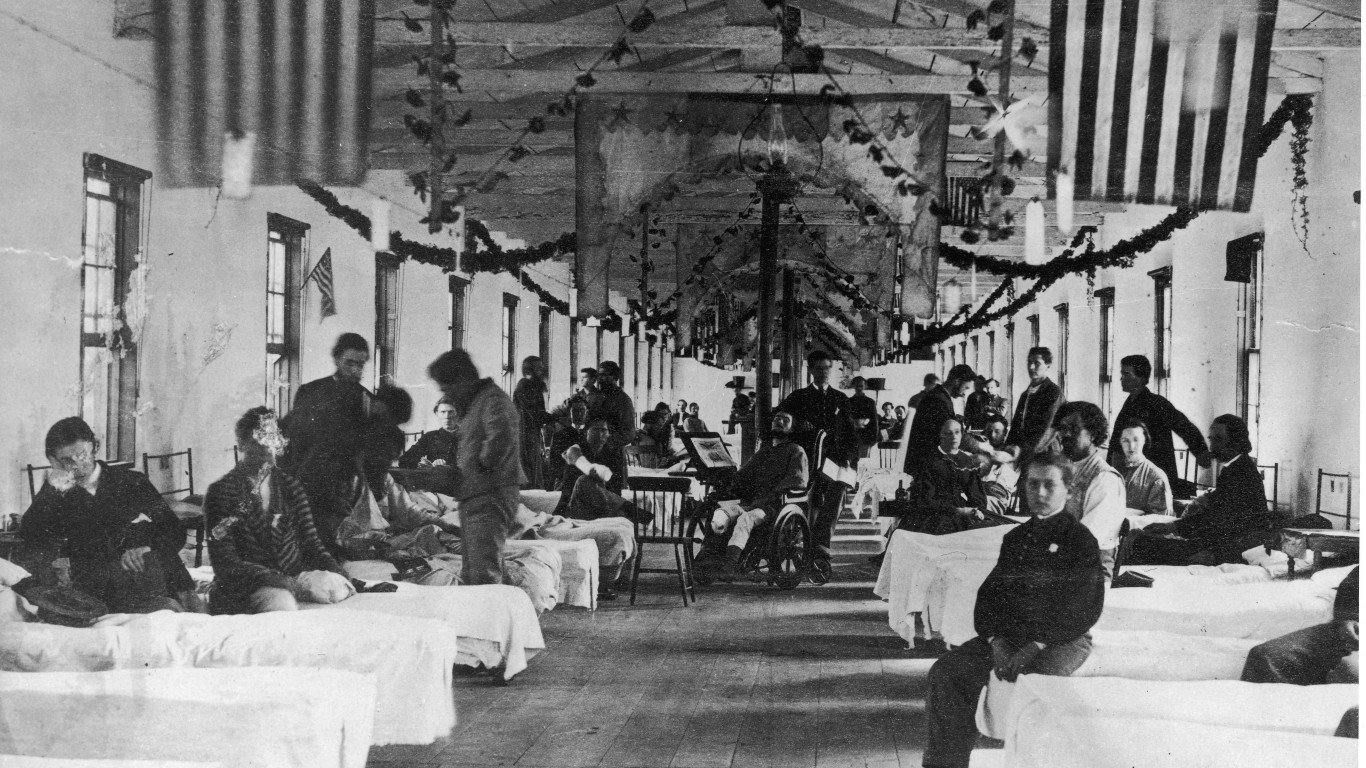
1862: A Washington D.C. hospital ward
Campbell General Hospital was a Civil War-era facility for Union soldiers in the nation’s capital, operating between 1862 and 1865. It was unique in having a theatre where plays were presented nightly for the patients, like those pictured here. The unusual American flag hanging from the rafters, in use in some places from 1861 to 1863, has 34 stars. The significance of the four stars in the middle isn’t certain, but they may represent Maryland, Delaware, Kentucky, and Missouri, which remained in the Union even though they were slave states.
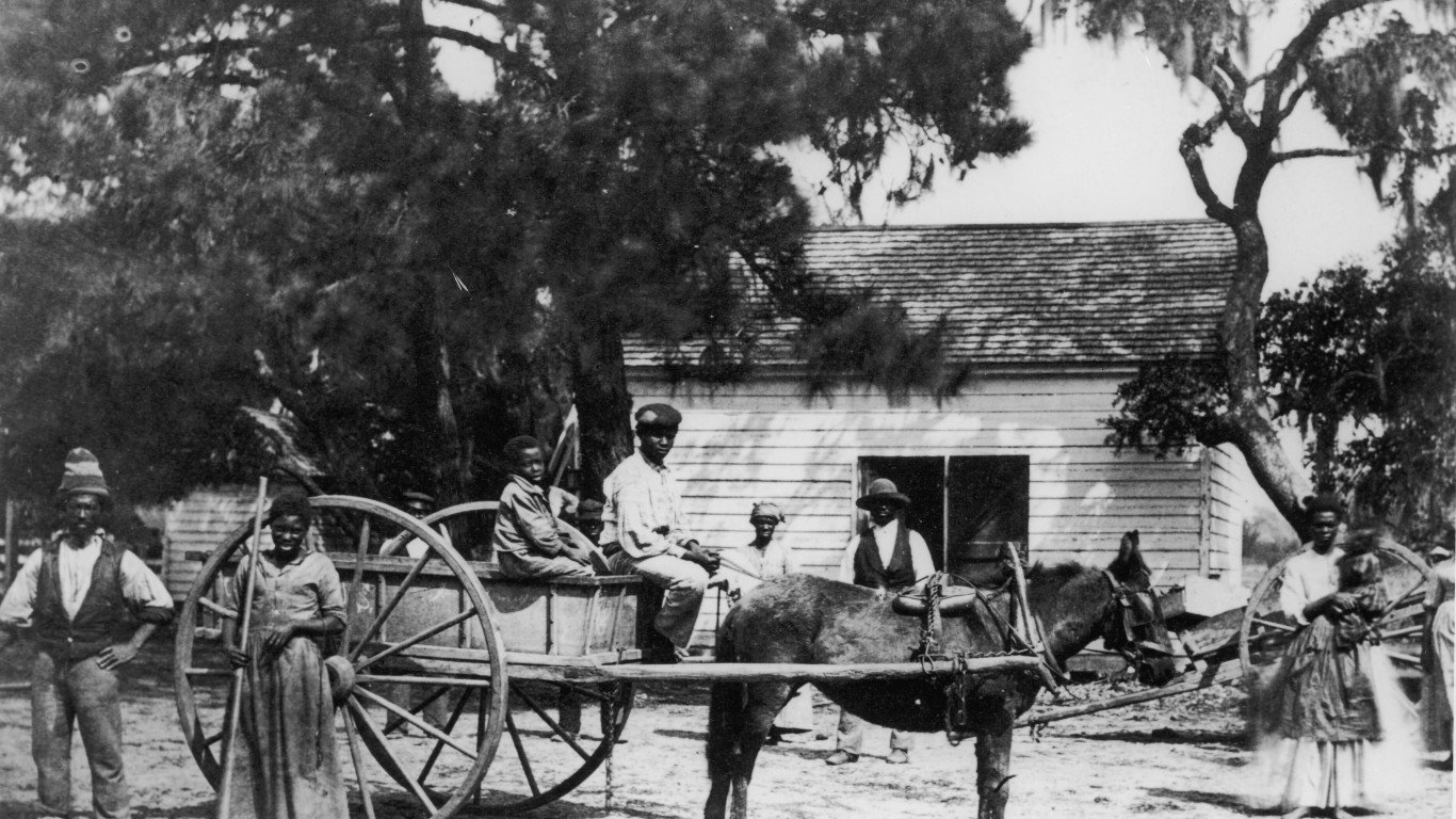
1862: Field workers on Edisto Island, South Carolina
The New Hampshire photographer Henry P. Moore traveled south during the Civil War to take pictures of the Third New Hampshire Regiment as they bivouacked on the South Carolina coast. At the same time, he also photographed slave life in the region, and took a particular interest in African-American farmers, like those in this image, after the Battle of Port Royal in November of 1861 left them free of their masters though not yet officially emancipated. This shot was taken on the former plantation of one James Hopkinson on Edisto, one of the state’s Sea Islands.
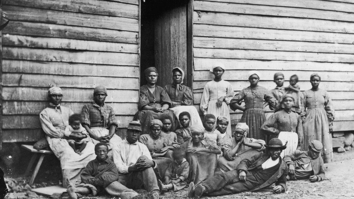
1862: Former slaves in Virginia
Taken after the Union Army had seized portions of southeastern Virginia during their Peninsular Campaign in 1862, this photograph shows a group of enslaved men, women, and children who sought refuge away from their masters’ plantations behind Union lines. While federal law dictated that escaped slaves be returned to their owners across the Mason-Dixon Line, the Union forces began labeling these people as “contrabands” or “contraband of war,” and enrolling them to support the war effort.
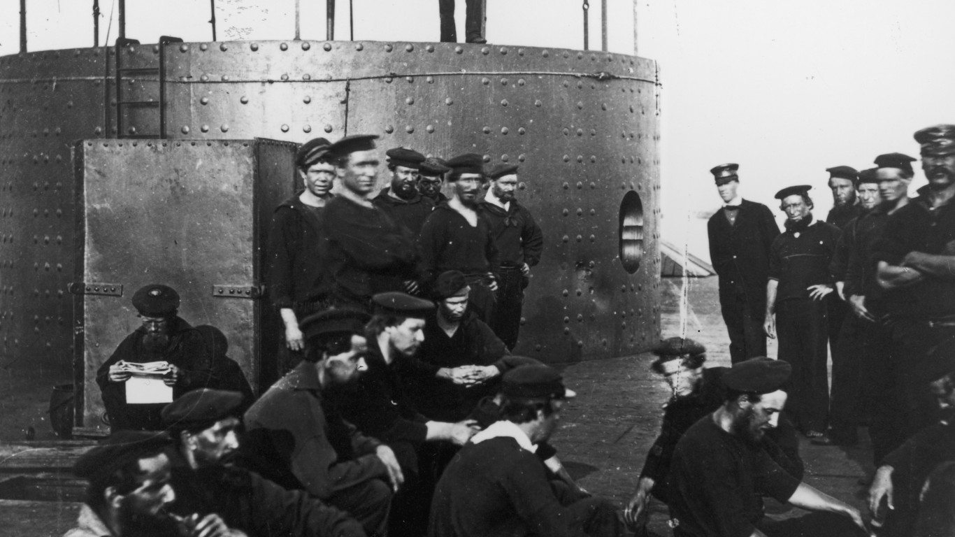
1862: The crew of the USS Monitor
Launched in January of 1862, the USS Monitor was the U.S. Navy’s first ironclad ship, and a participant in the historic Battle of Hampton Roads on Mar. 9 of that year, when it fought its Confederate counterpart, the CSS Virginia (built on the hull of the scuttled USS Merrimack). This photo shows the crew of the Monitor relaxing on the James River on July 9. The ship had a short lifespan: It was lost at sea in December that same year.
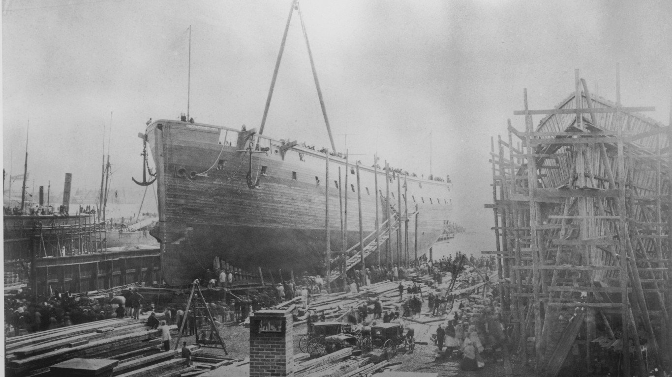
1863: The William H. Webb shipyard in New York City
William Henry Webb has been called America’s first true naval architect. Inheriting the Webb & Allen shipyard from his father in 1840 and renaming it for himself, he became the country’s most successful shipbuilder. He designed scores of vessels and his enterprise turned out some 133 ships between the time he took it over and 1865. This image shows the construction of the Re Don Luigi di Portogallo, an ironclad built for the Italian government.
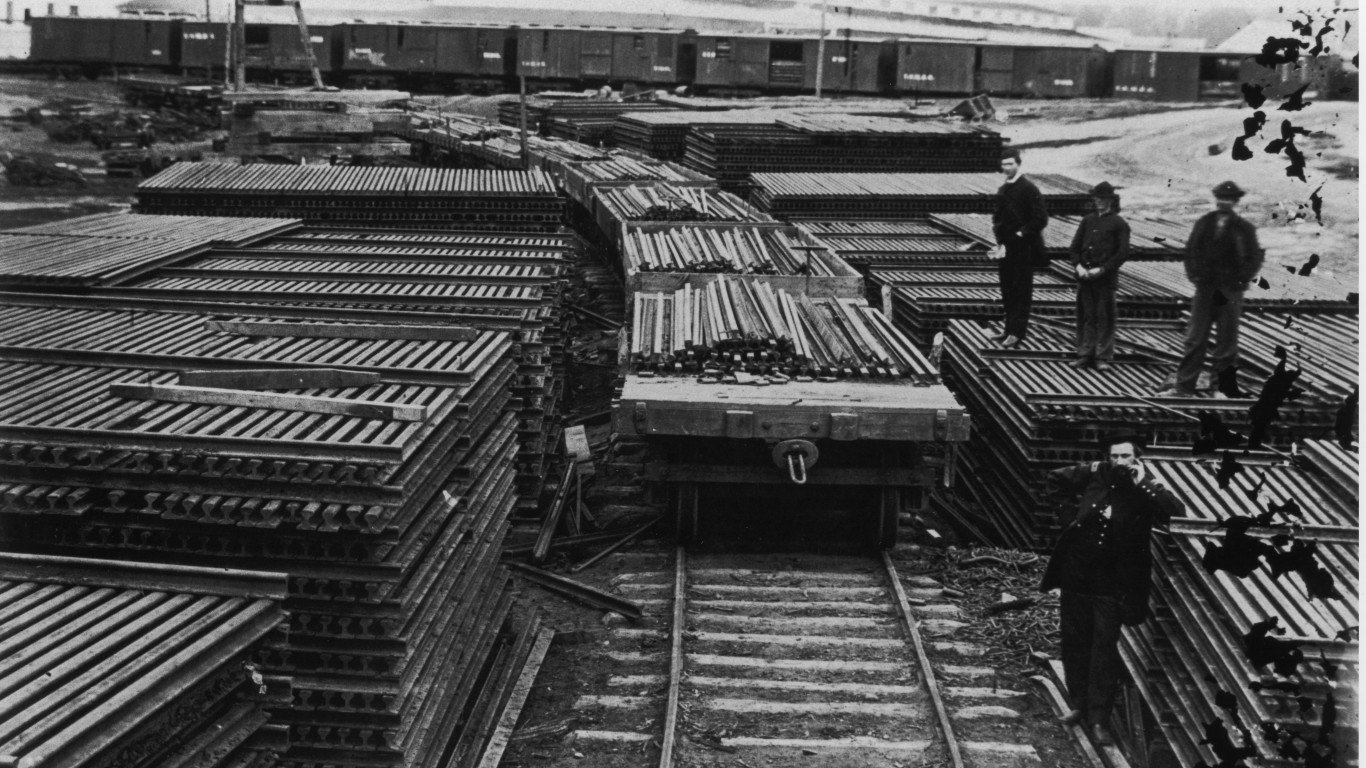
1863: U.S. Military Railroad ties in Alexandria, Virginia
The US Military Rail Road (USMRR) was an organization established by the United States War Department to maintain and operate any Confederate rail lines seized by the Union Army during the Civil War. Established in February, 1862, the USMRR would come to be responsible for over 400 locomotives and over 6,000 railway cars. In this picture from a USMRR rail yard in Arlington, Va, one can see the supply of rails kept on hand to make sure that the lines could continue to operate to the Union’s benefit.
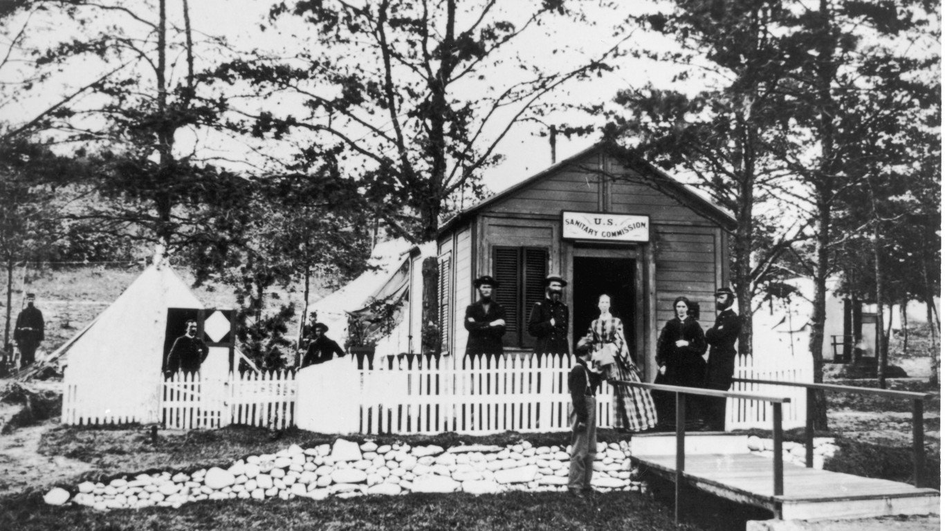
1864: The U.S. Sanitary Commission in City Point, Virginia
The United States Sanitary Commission was a volunteer relief organization established in 1861 to provide moral and physical support to sick and wounded Union soldiers during the Civil War. One of its initiatives was sending canned and pickled produce to the front for the army’s nourishment. The soldiers and volunteers pictured here are at the Commission facility in City Point, Va., since renamed Hopewell.
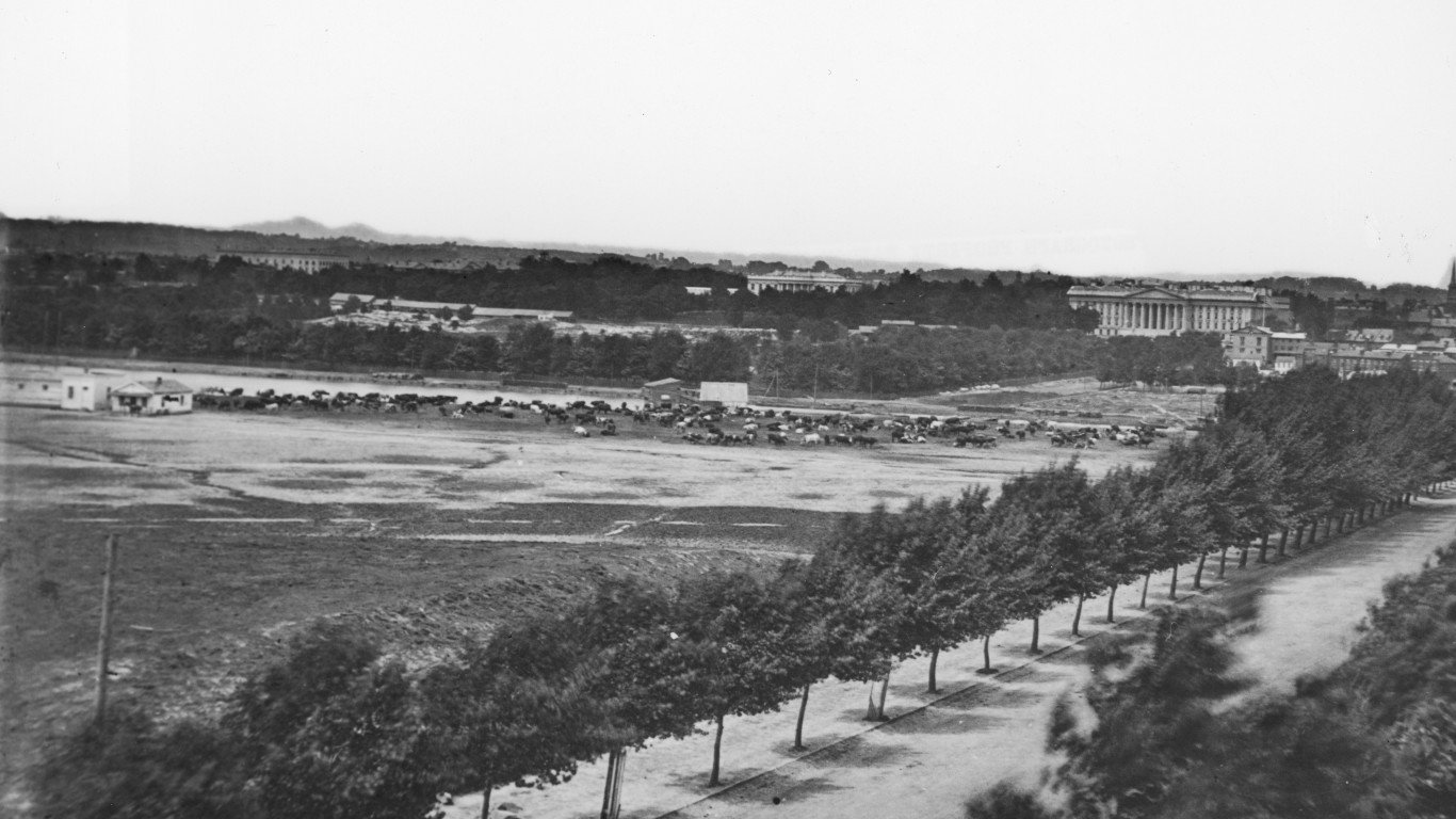
1865: Cattle grazing in Washington D.C.
The grounds where the unfinished Washington Monument stood were used during the Civil War for military drills and for the grazing and slaughter of cattle (as many as 10,000 fed there at one time, according to the poet Walt Whitman). The large building in the background on the right is the U.S. Treasury, and the top of the White House is just visible to the left, above the trees.
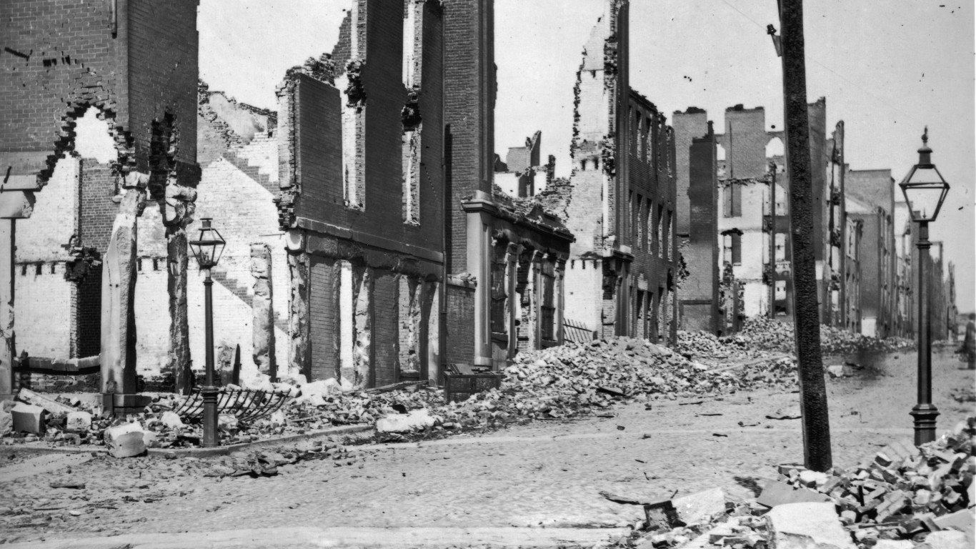
1865: Ruined buildings in Richmond, Virginia
Richmond served as the capital of the Confederate States of America for all but the first few months of the Civil War, and was also one of the South’s most important cities economically, as a railroad hub and a center of iron-making and other industries. When it fell to the Union army in April 1865, much of the city was destroyed — though not always by the Union. Before evacuating, the Confederates set fire to buildings holding stores of tobacco and foodstuffs to keep supplies out of Union hands, and the flames spread through the entire downtown business district and destroyed the city’s ironworks.
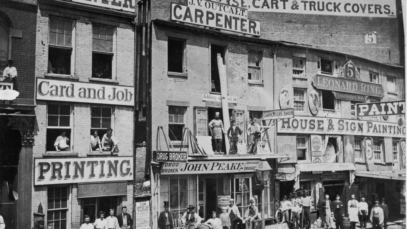
1865: A view of Hudson Street, New York City
Because of its proximity to the piers along the Hudson River, the area of Manhattan now known as TriBeCa (for “Triangle Below Canal Street”) was a thriving business district in the mid-19th century. No. 5 Hudson, seen at the right of this image, is now the site of Kings Pharmacy, a well-loved neighborhood business.
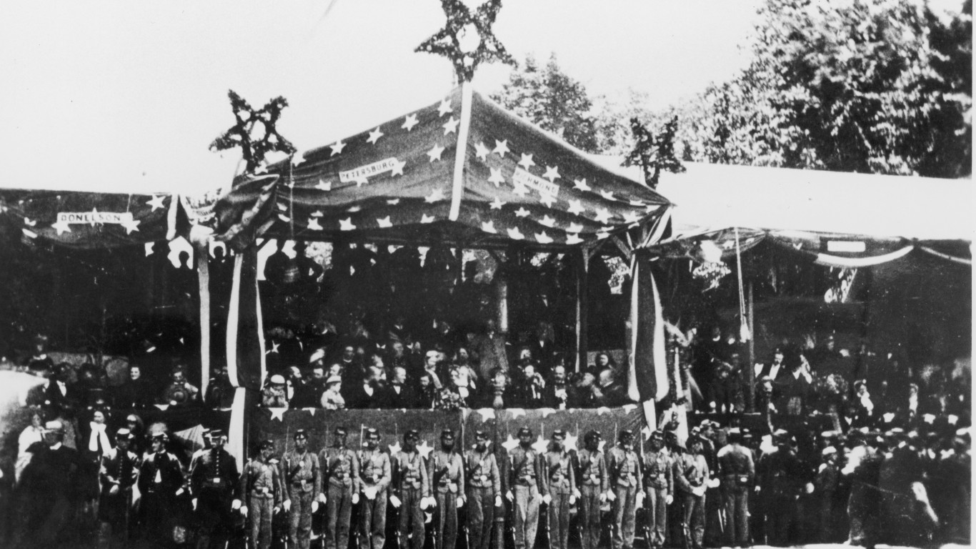
1865: The Grand Review of the Armies
The Grand Review of the Armies was a two-day military parade held in Washington D.C. to celebrate the defeat of the Confederacy in the Civil War. On May 23, 1865, 80,000 soldiers in the Army of the Potomac marched down Pennsylvania Avenue from Capitol Hill to the White House, where General Ulysses S. Grant, commander of the victorious Union forces, and the newly inaugurated President Andrew Johnson (Abraham Lincoln had been assassinated only a month earlier) were among the dignitaries on the reviewing stand. The next day, the 65,000 men of the Army of Tennessee and the Army of Georgia repeated the march.
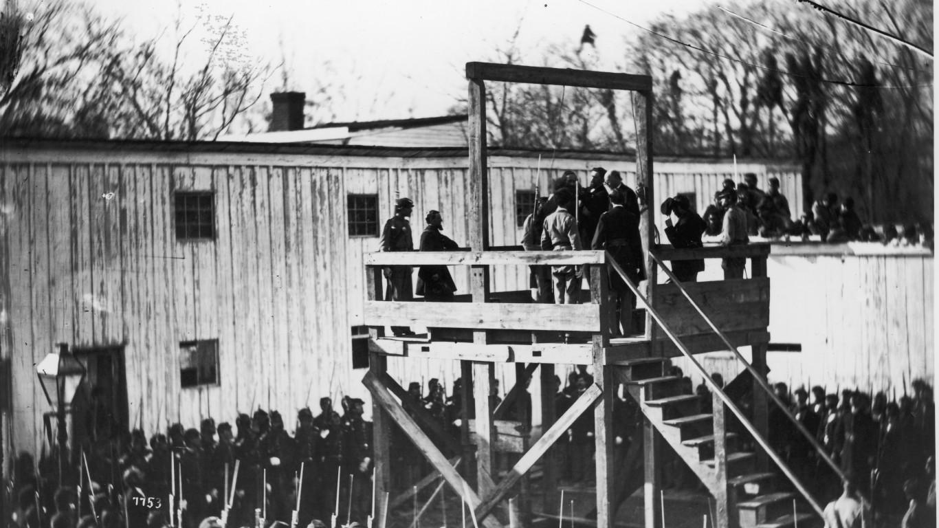
1865: The execution of a Confederate war criminal
The notorious Andersonville Prison, officially called Camp Sumter, was a Confederate prisoner-of-war facility in Georgia. As many as 45,000 captured Union soldiers were incarcerated there in 1864 and ’65 — about four times its capacity. Conditions were horrible. Food and water were insufficient and disease was rampant among the prisoners. Almost 13,000 of them died. After the war, the commandant of the camp, Captain Henry Wirz, was tried and convicted for war crimes for allowing the mistreatment. This photograph shows him being hanged in Washington D.C. on Nov. 10, 1865.
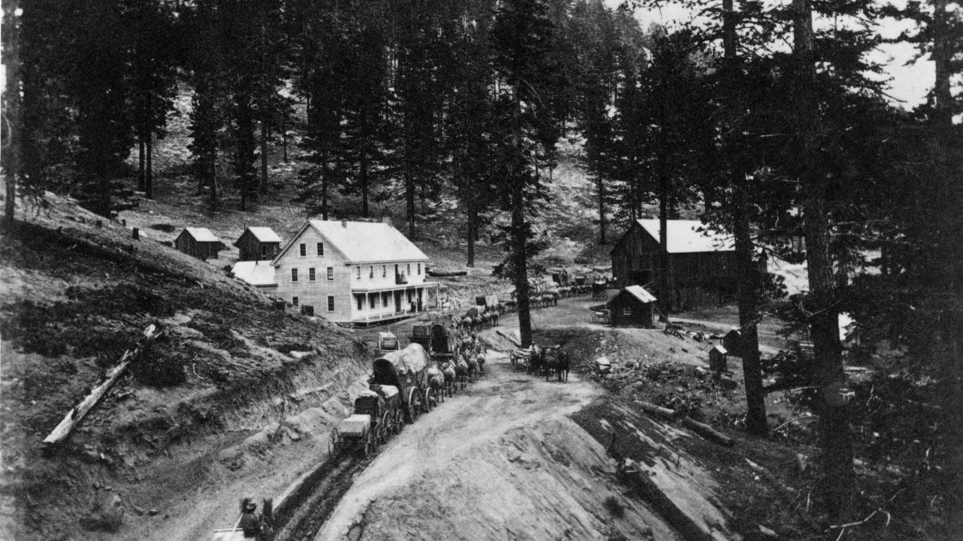
1866: Freight wagons near Lake Tahoe, California
In this image, wagons carrying supplies to the Comstock Lode, a silver strike in Virginia City, Nev., approach Swift’s Station on the Carson and Lake Bigler Road in the Sierra Nevadas near the eastern shore of Lake Tahoe, a body of water that straddles the Nevada-California border. Swift’s was an inn where teamsters stopped near the crest of the mountain.
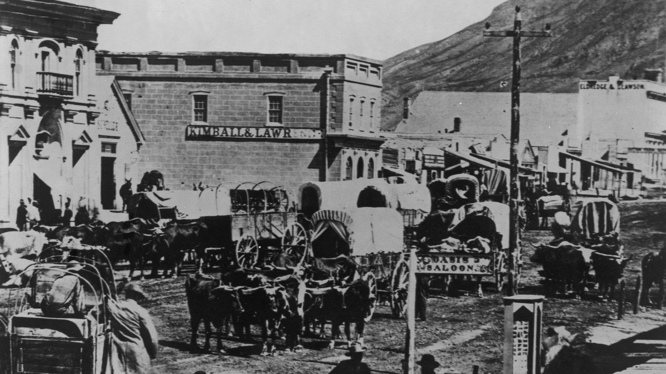
1867: A view of Main Street, Salt Lake City
Today a city of more than 200,000 people and the capital of Utah, Salt Lake City was founded in 1847 by Mormon pioneers from Illinois fleeing persecution for their religious beliefs. At the time, the area was a Mexican territory, though it came under American control the following year. Though Utah wouldn’t become a state until 1896, Salt Lake City was beginning to thrive as a railroad hub and a base for the mining of precious metals and minerals at the time this photograph was taken.
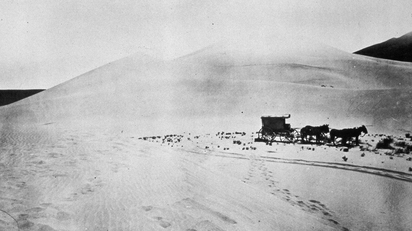
1868: A covered wagon in the Carson Desert, Nevada
This covered wagon traveling across the Carson Desert in Nevada is actually a mobile darkroom belonging to photographer Timothy H. O’Sullivan. O’Sullivan came to prominence working for famed Civil War photographer Mathew Brady. Subsequently, from 1867 to 1869, he became the official photographer for the U.S. Geological Exploration of the 40th parallel. He is considered to be a pioneer of geophotography, the recording of geologically significant features of the landscape.
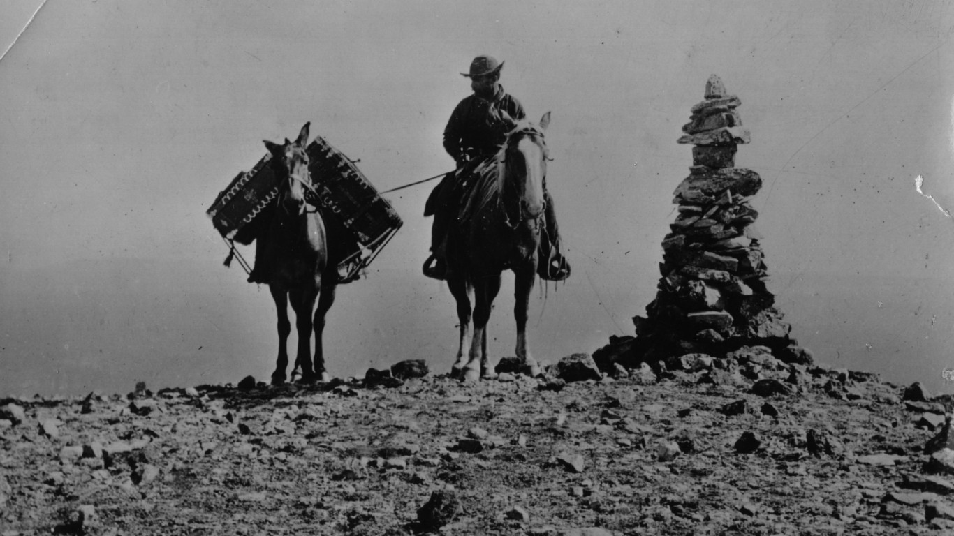
1870: Photographer William Henry Jackson on Mount Washburn
This image shows the noted geological photographer William Henry Jackson carrying his photographic equipment on horseback over the summit of Mount Washburn, a prominent peak in what was about to become (or, depending on the exact date of this image, had just become) Yellowstone National Park — the nation’s first national park, established by President Ulysses S. Grant in March 1872.
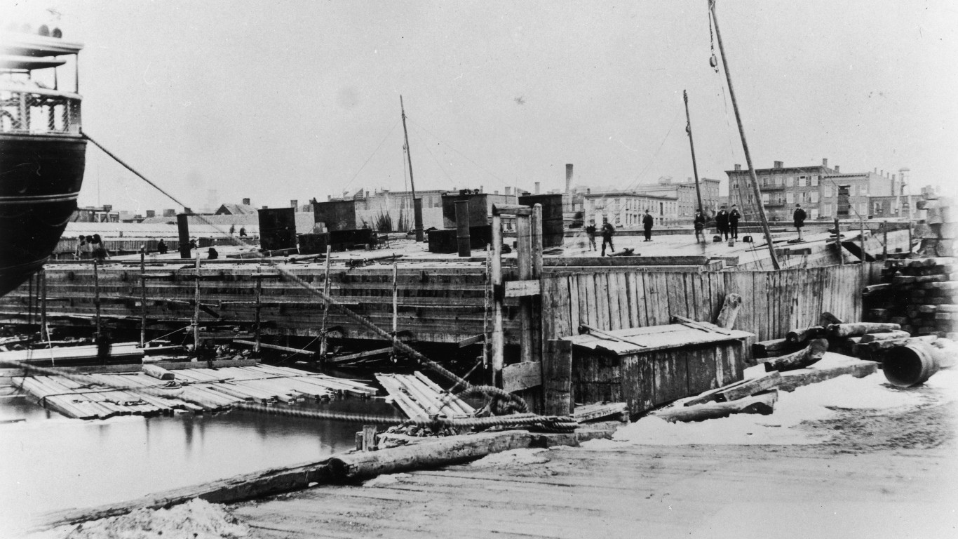
1870: The Brooklyn Bridge under construction
The construction of this emblematic span, one of America’s most famous bridges, began in 1870. A wire rope suspension bridge, it was designed by a German-born civil engineer named John Augustus Roebling. In the early stages of the project, depicted here, a caisson (a sealed underwater foundation) was launched into the East River at Greenpoint in Brooklyn.
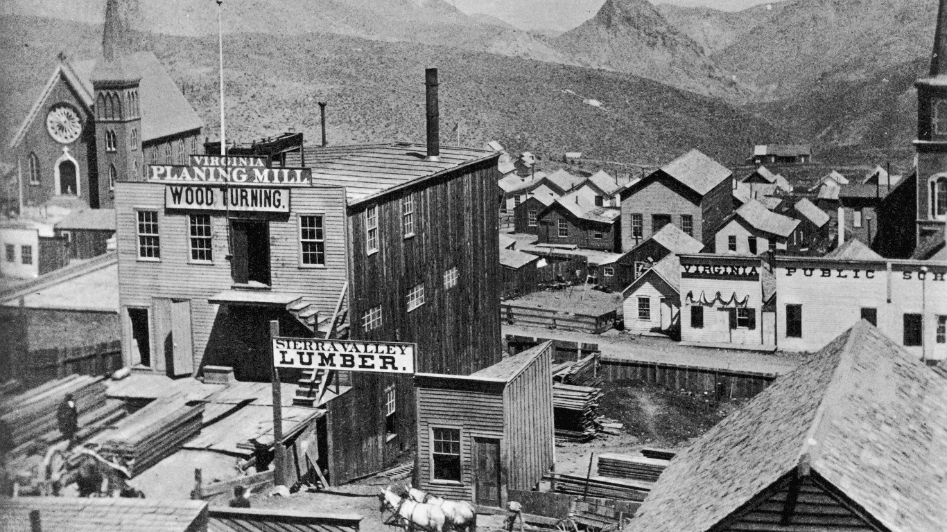
1870: View of Virginia City, Nevada
Virginia City, then part of the Utah Territory, became a boomtown after the discovery of the Comstock Lode — the first major vein of silver ore found in America. By the mid-1870s, the town had a population of about 25,000 and a thriving lumber industry, as this view showing the Virginia Planing Mill and Sierra Valley Lumber suggests. By the late 1870s, the silver began to run out, and the population declined; today the town has about 855 inhabitants.
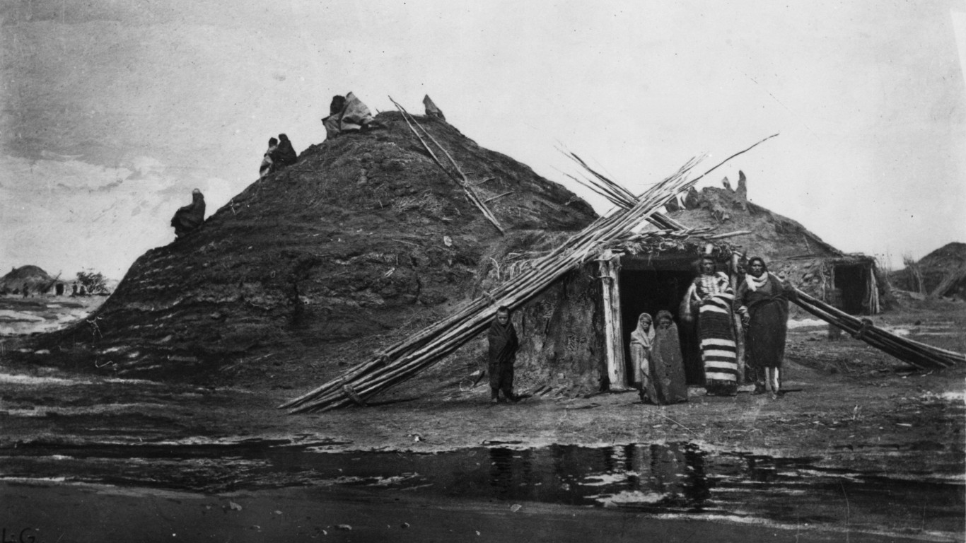
1871: A Pawnee family in Loup, Nebraska
The photographer William Henry Jackson, whose images chronicled many aspects of American life and the country’s landscape, captured this image of a Pawnee Indian family outside their earthen lodge in Loup County, Nebraska, named for a tribal band known as the Wolf Pawnee (Loup Pawnee in French). The Pawnee people are a Central Plains tribe once based in Kansas and Nebraska, who relocated to Indian Territory, in what is now Oklahoma, in 1875.
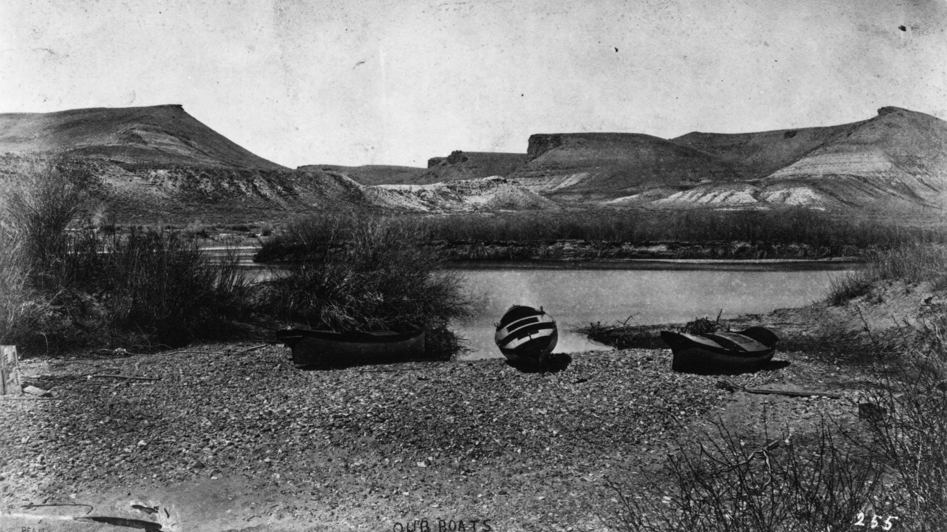
1872: The Colorado Valley, Texas
The geologist John Wesley Powell led several exploratory missions along the course of the Colorado River in the American Southwest, one in 1869 — the first official U.S. government expedition through the Grand Canyon — and another in 1871 and ’72. This image, taken by photographer E.O. Beaman, is from the second trip. Its exact location along the river is unknown.
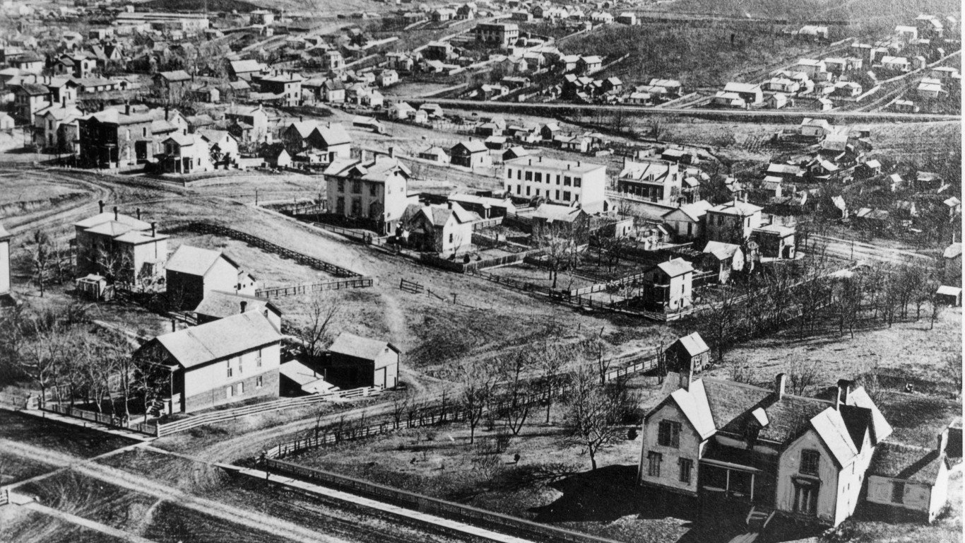
1876: An aerial view of Omaha, Nebraska
Nebraska was admitted to the union as the 37th state in 1867. Though Omaha hadn’t yet become a major meatpacking capital (by the early 20th century, it was home to four of the country’s five major pork processing plants), it had begun to thrive when the westward construction of the transcontinental railroad began in the city in 1866. This aerial view was taken from the tower of Omaha High School.
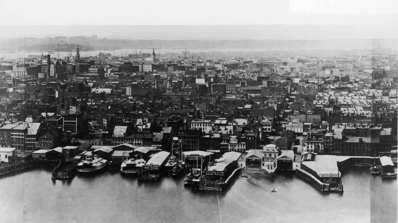
1876: New York City seen from the Brooklyn Bridge
Manhattan already had a population of almost a million people when this panoramic view of the city was taken from the Brooklyn Tower on the eastern end of the Brooklyn Bridge — then known as the New York and Brooklyn Bridge (Brooklyn wasn’t annexed to New York City until 1898) or East River Bridge. The suspension cables hadn’t been installed on the bridge yet, which didn’t open officially until 1883.
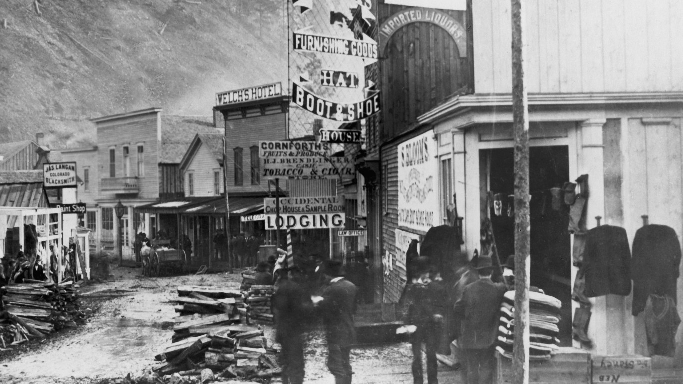
1877: A street in Deadwood, South Dakota
Frank Jay Haynes, who was the official photographer for both Yellowstone National Park and the Northern Pacific Railroad, maintained studios in Minnesota and North Dakota and had another one in a Northern Pacific railroad car, which covered much of the Northwest. The Black Hills Gold Rush had turned Deadwood into a boom town by the time this photo was taken. Once home to such Old West legends as Calamity Jane, Wyatt Earp, and Wild Bill Hickok, the town, in a fictionalized version, was the setting for the HBO series “Deadwood.”
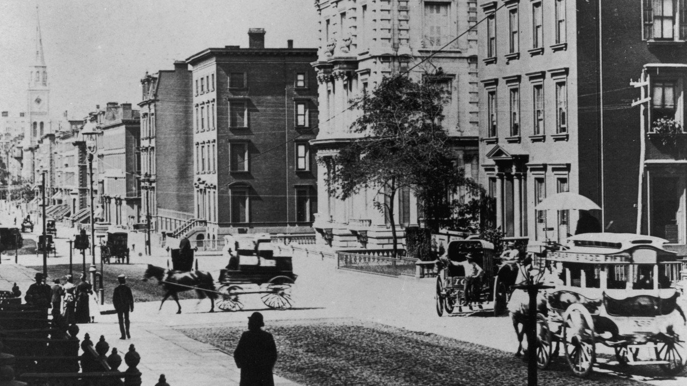
1880: Looking south on Fifth Avenue, New York City
More than a million people crowded the streets of Manhattan when this picture was taken, looking south along Fifth Avenue from 35th Street. The large building that’s second from the right was the fabled A.T. Stewart mansion at the corner of Fifth and 34th. Stewart, an Irish immigrant, turned a dry goods shop into a multimillion-dollar international business, becoming one of America’s richest men. In 1869, he began construction on what was to become one of the city’s most spectacular private houses, a four-story white marble structure that was said to have cost $2 million (more than $50 million today). Stewart died in 1876, but his widow, Cornelia, would have been living here when this photo was taken. She died in 1886, and 1901 the mansion was demolished.
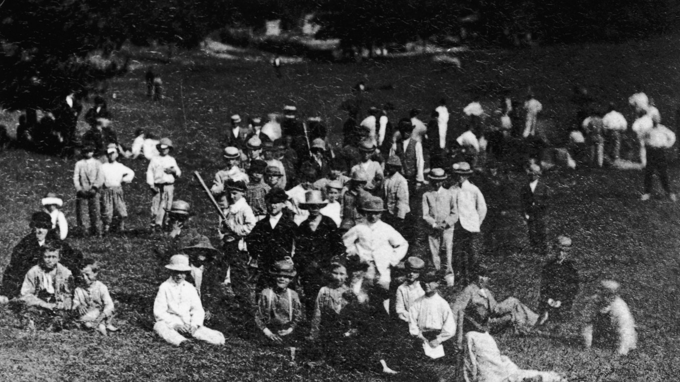
1880: Children on the lawn in Central Park, New York City
Famed landscape architects Frederick Law Olmsted and Calvert Vaux designed this landmark public park in 1857, and the first portion opened the following year (though It took another 18 years for the park to be completed). It became increasingly popular with the general public — like the group of children (with a few adults) pictured here — but the city government neglected its upkeep, and it languished until the early 20th century when several civic groups began helping to revive it.
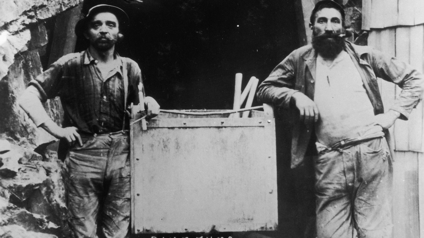
1882: Gold miners in Placer County, California
Placer County takes its name from placer deposits, accumulations of gravel or sand containing gold or other valuable minerals. This region, west of Lake Tahoe, was a major placer mining area. The Last Chance district is said to have been named by a starving miner who used his last bullet to kill a deer to eat. These two Last Chance miners are wearing Levi jeans from San Francisco, first sold in the 1870s.
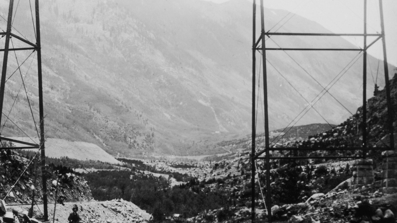
1884: A view of Devil’s Gate High Bridge in Colorado
This dramatically positioned railway bridge was built over the Clear Creek gorge, west of Denver, in 1884. It was one of four bridges constructed for the narrow-gauge Georgetown Loop Railroad, which ran between mining towns in the Rocky Mountains. The bridges were considered a remarkable feat of engineering when they were built. The line was dismantled in 1939, but later restored as a tourist attraction.
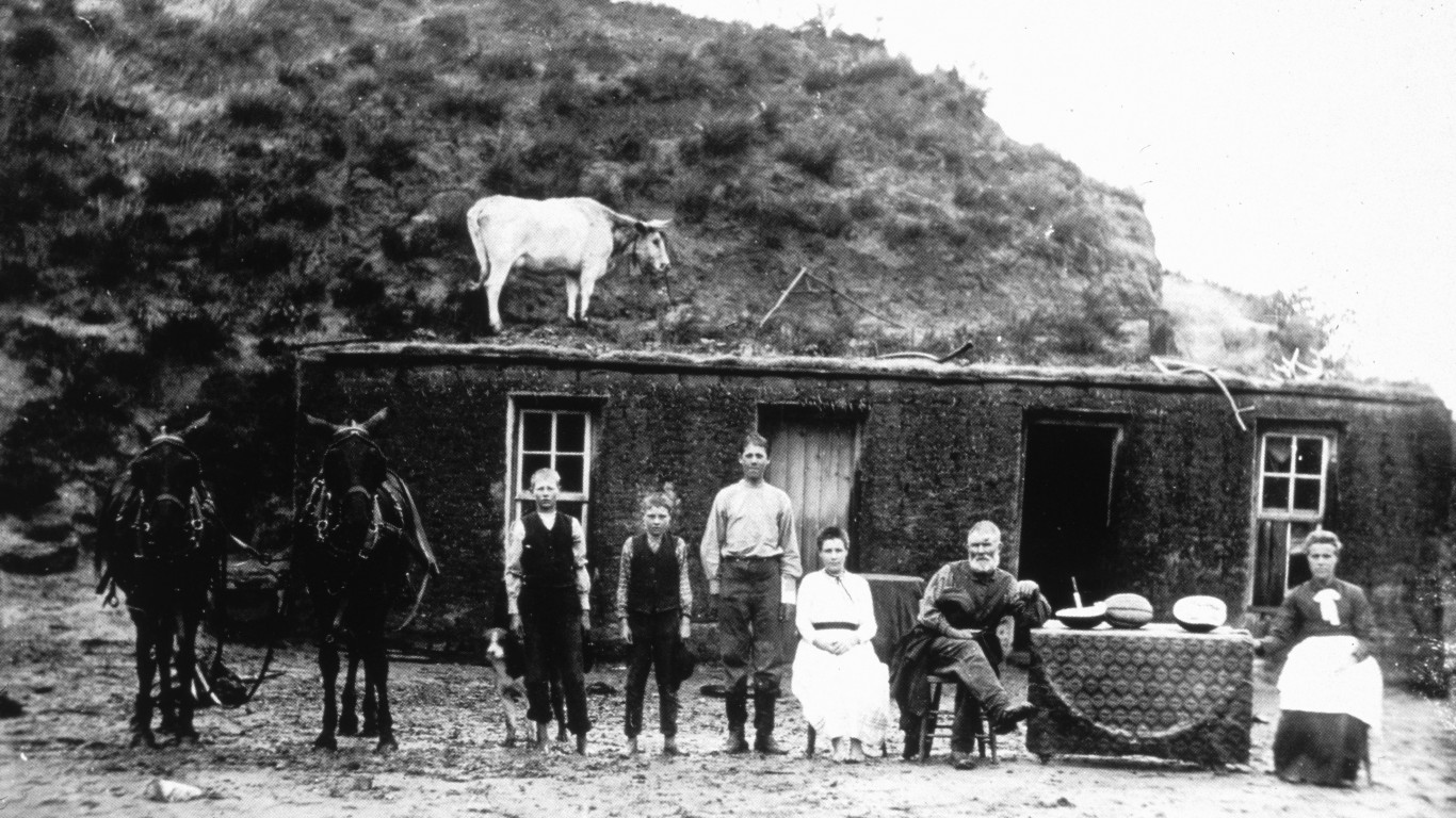
1886: A pioneer family on the Great Plains
Because there were few trees on the Great Plains, homesteaders — like the Sylvester Rawding family pictured here, north of Sargent in Custer County, Nebraska — often built houses like this one from sod, hardened earth bound together by the root systems of grasses. While it appears that a cow is standing on the roof, it’s actually on the hillside just behind the house. The photo was taken by Solomon D. Butcher, a failed homesteader himself whose images documented the pioneers in the region.
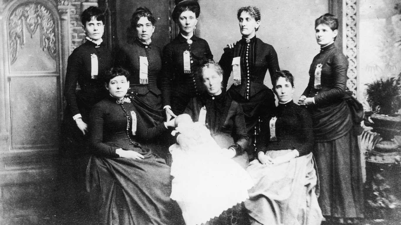
1886: Delegates to the Knights of Labor convention
These women are delegates to the 1886 convention of the Knights of Labor, also known as Noble and Holy Order of the Knights of Labor, in Richmond, Virginia. The group was one of the most important 19th-century American labor organizations. Founded by Uriah Smith Stephens and eight other Philadelphia tailors in 1869, the Knights proposed a platform that called for an end to child and convict labor, equal pay for women, a progressive income tax, and the cooperative employer-employee ownership of mines and factories.
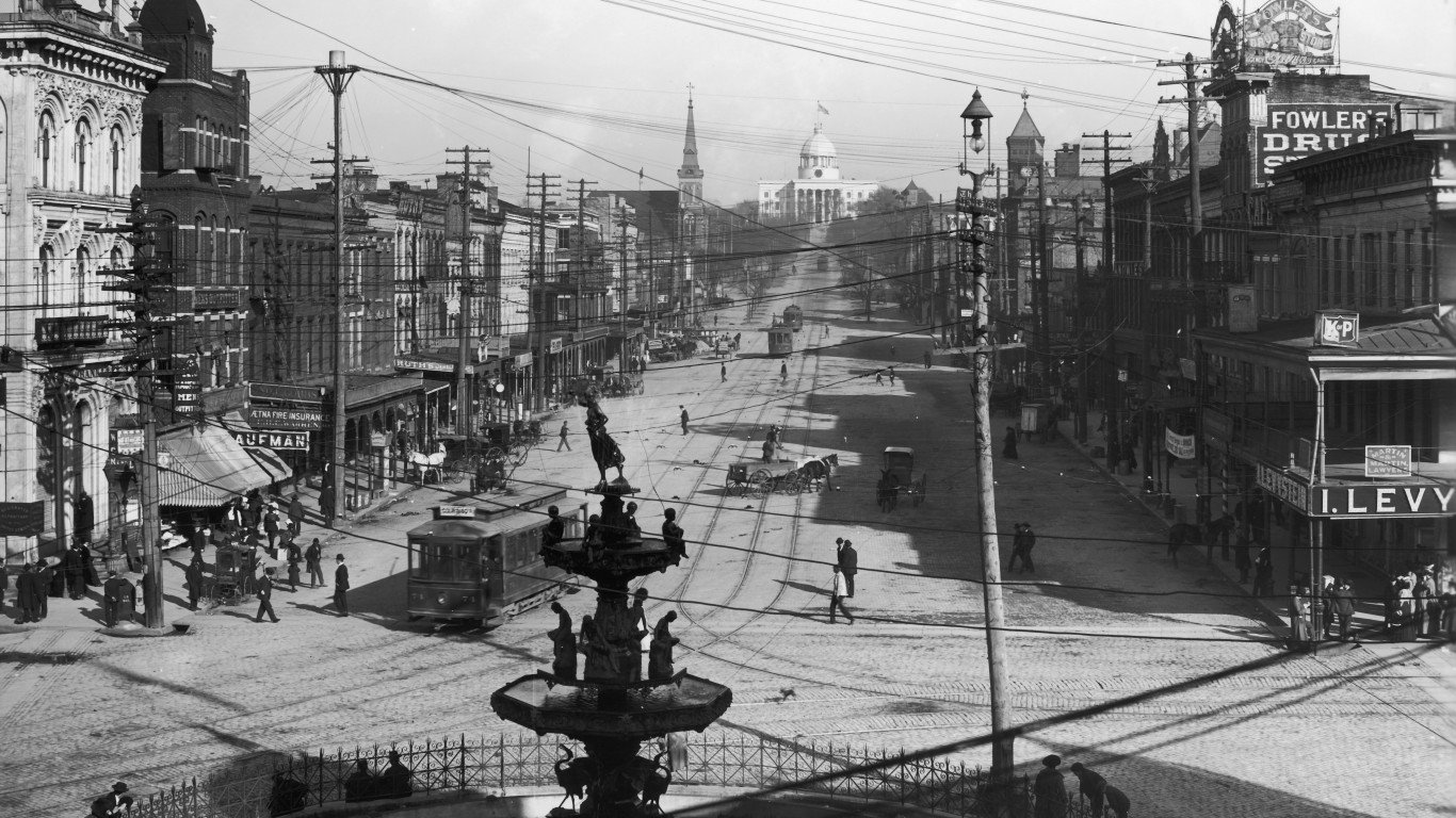
1886: A view of the state capitol building, Montgomery, Alabama
This photograph shows two important features of Montgomery in the mid to late 1800s: the historic capitol building, completed in 1851, and the Capital City Street Railway, also known as the Lightning Route. This was Montgomery’s city-wide streetcar system, which operated from 1886 until 1936. The city has a place in Civil War history, as the Confederate States of America was officially established there in February of 1861, and Montgomery was its headquarters until the rebel government moved to Richmond, Virginia, in May of that year.
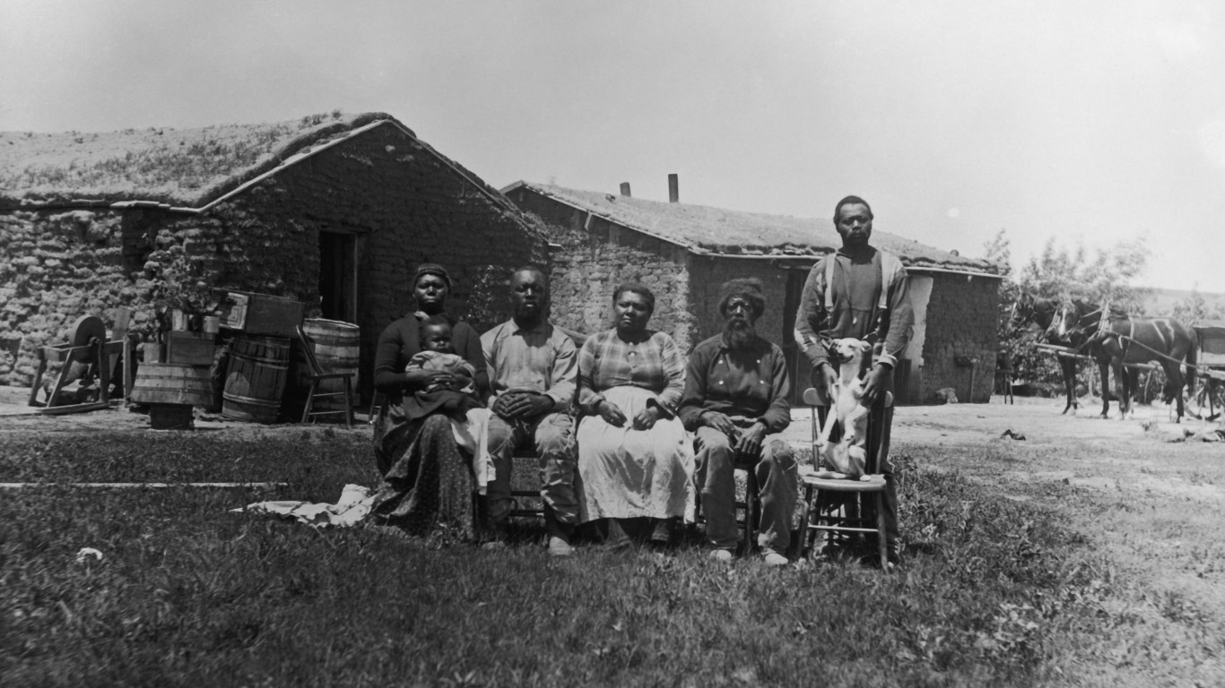
1887: A family of homesteaders in Nebraska
Another one of Solomon D. Butcher’s portraits of homesteading families, this one depicts the family of Jerry Shores in front of their home near Westerville, in Custer Country, Nebraska. Shores was one of a number of former slaves who homesteaded in the county. His property abutted that of his brothers, Moses Speese and Henry Webb (each had different last names, taken from their different owners).

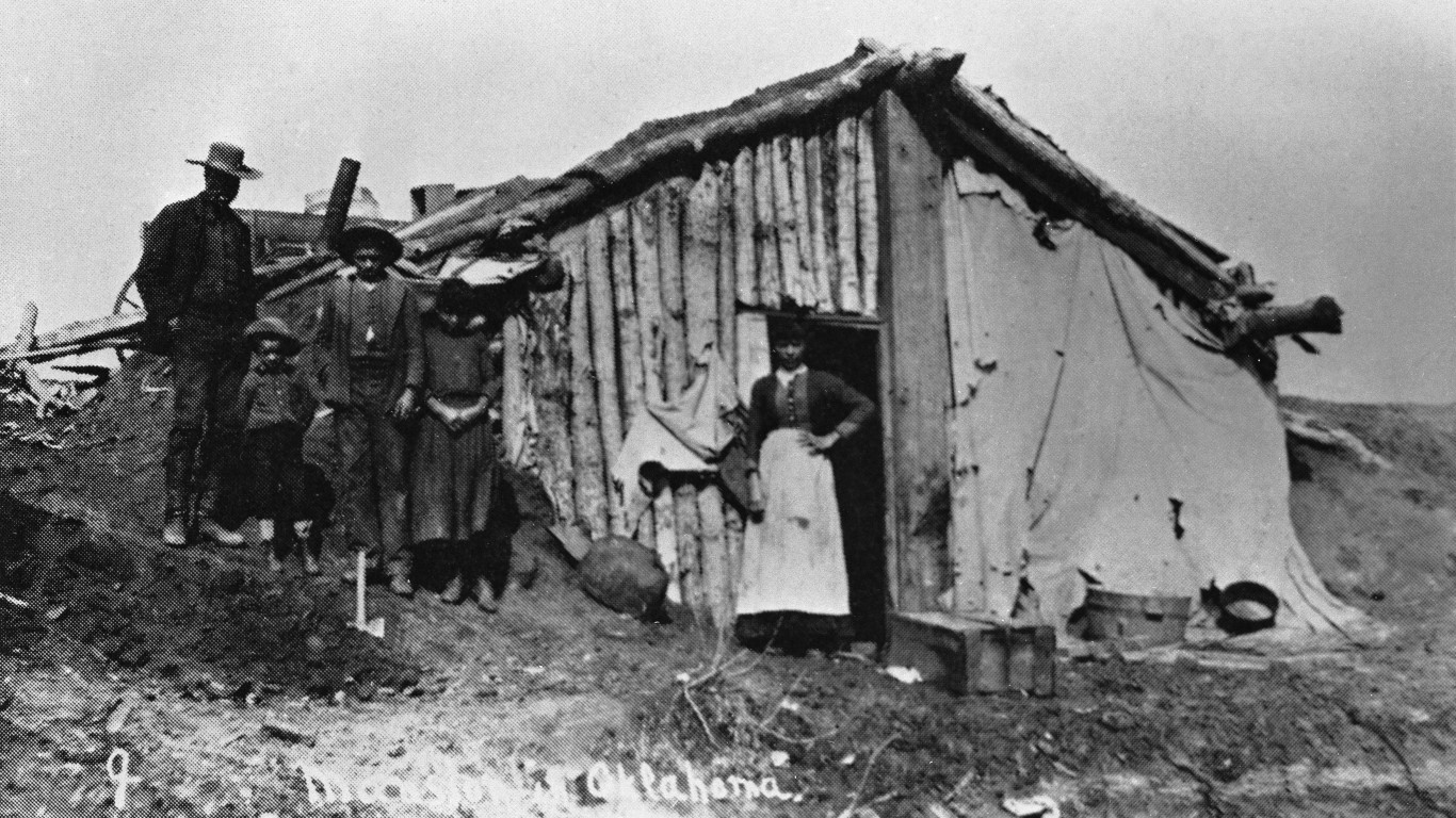
1889: A ramshackle homestead shack outside Guthrie, Oklahoma
The so-called Unassigned Lands was an area of the Oklahoma Territory opened to the Land Rush of 1889, a free-for-all homesteading event at which about 50,000 people lined up to race into the region to claim lots of up to 160 acres each. Harmon T. Swearingen, who had a photography studio in Guthrie and captured many images of the town as it grew, took this picture of homesteaders who took up residence in this shack outside Guthrie in order to certify their claim.
1890: Outside the Pullman factory in Chicago
Engineer and industrialist George Pullman founded the Pullman Car Company in 1862 to manufacture railroad sleeping cars. In 1880, he built a “company town” called Pullman on Chicago’s Southside. Workers were housed in accommodations that included indoor plumbing and gas for heating and cooking, luxuries for the working class at the time, and the complex included ornamental gardens and parks.
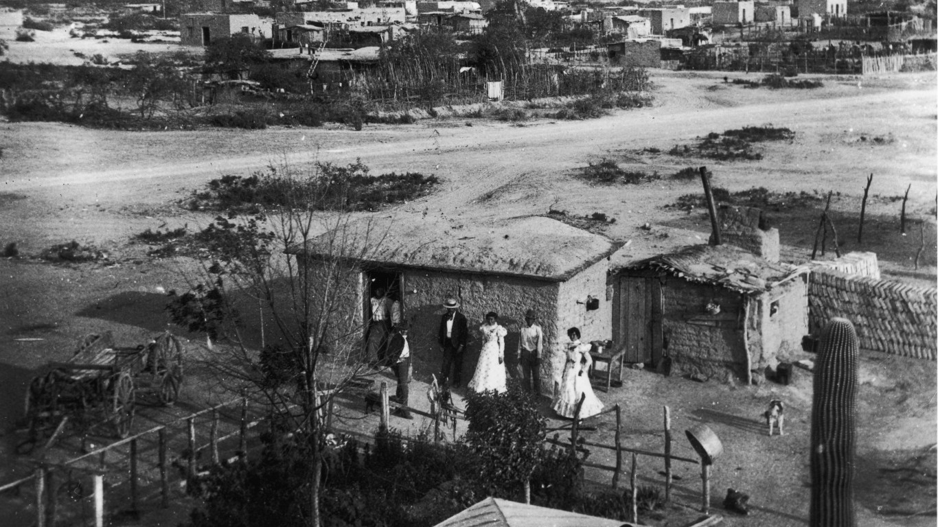
1890: A home in Tucson, Arizona
There is little information available about this photograph, other than the names of three of the seven people pictured (there appear to be two just inside the doorframe). They are described as “A.S Jones and Mexican friends Tony Salas and Maria Rodriguez standing outside of their home.” The house, apparently on the outskirts of town, is made from adobe brick.
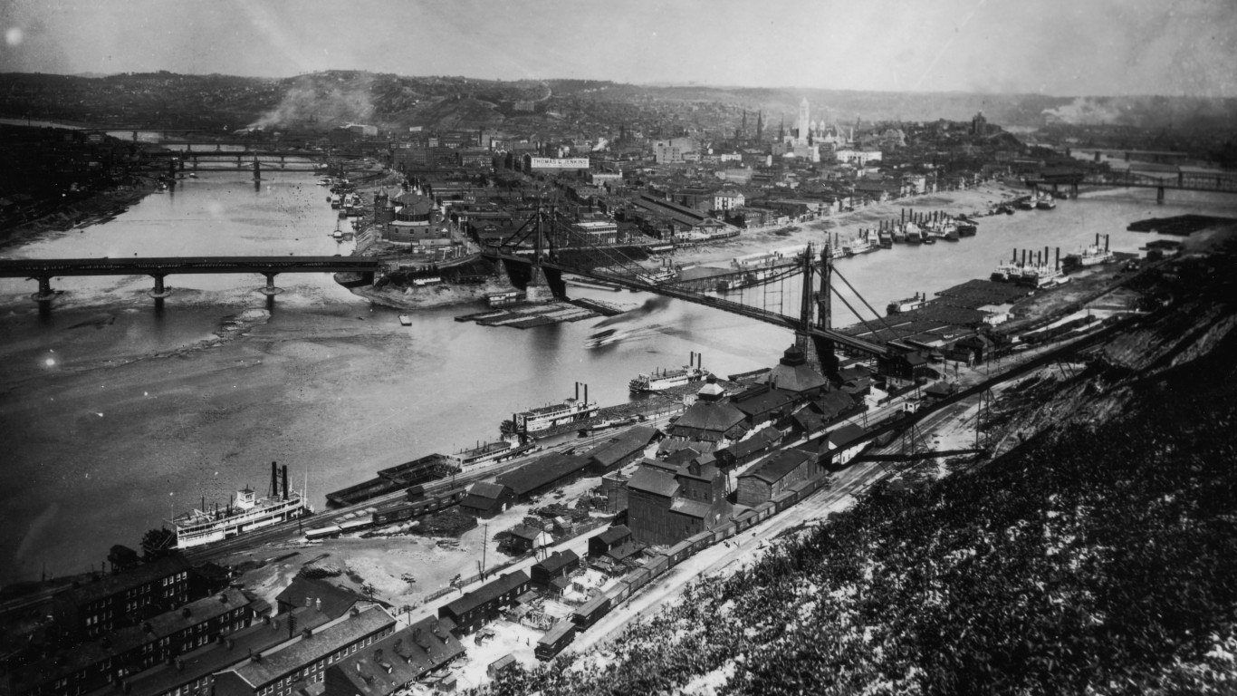
1890: The confluence of the Allegheny and Monongahela rivers
The 981-mile-long Ohio River flows through or along the border of six states before emptying into the Mississippi River in southern Illinois. This aerial view shows the point at which the Ohio forms, at the confluence of the Allegheny and Monongahela rivers, at what is now Point State Park in Pittsburgh.
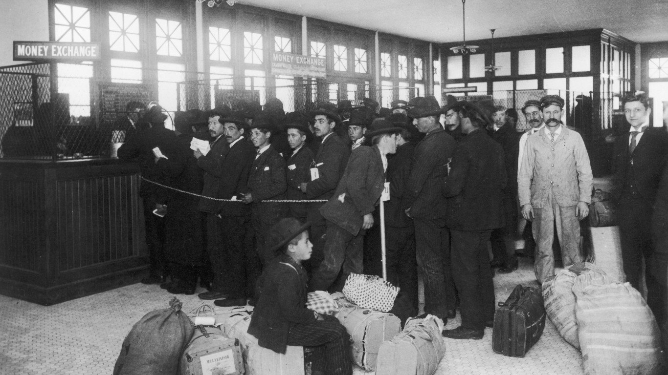
1892: Immigrants changing money on Ellis Island, New York
The first immigration station in New York was established at Castle Clinton at the southern end of Manhattan. Construction of a new facility began on Ellis Island, off the coast of New Jersey, in 1890, and the U.S. government opened the Ellis Island Immigration Station on Jan. 1, 1892. Once an immigrant had been admitted to the country, the next stop was this Money Exchange, where foreign currencies, gold, and silver could be converted into American dollars. The rate of exchange varied from day to day and was inscribed on a blackboard.
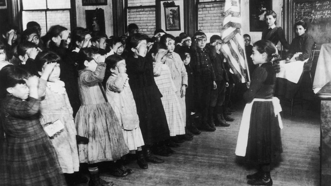
1892: School children saluting the American flag
The Danish-American journalist and social activist Jacob Riis was also a serious photographer, taking many images of New York tenement life and other scenes. This is his photograph of young school children saluting the American flag at the Fourteenth Ward Industrial School on Mott Street, in the Manhattan neighborhood now called Nolita. The school was sponsored by millionaire John Jacob Astor III.
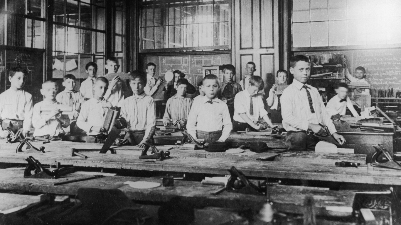
1892: Boys in a woodworking class, New York City
This image of schoolboys studying woodworking in a manual training class at an unnamed school in New York City might have been taken by Jacob Riis. The manual training movement, which grew popular in the 1870s, wasn’t geared towards any particular trade but was based on the idea that teaching the skills associated with wood- and metalworking would improve not only hand-eye coordination but also powers of observation and judgment among students.
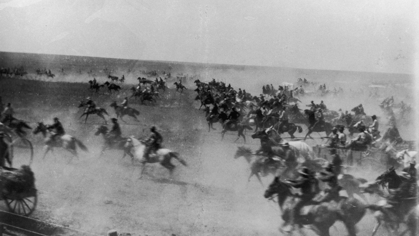
1893: A horse race in the Cherokee Outlet, Oklahoma
The Cherokee Outlet Opening, on Sept. 16, 1893, was the fourth and biggest land run — basically a race by would-be homesteaders to claim land — in Oklahoma. This photo was taken about ten seconds after the starting gun set off the race. According to the Oklahoma Historical Society, “Economic pressures plus poor planning and inadequate enforcement by federal agencies made it even more chaotic than earlier runs, resulting in massive fraud, widespread suffering, and a number of deaths.”
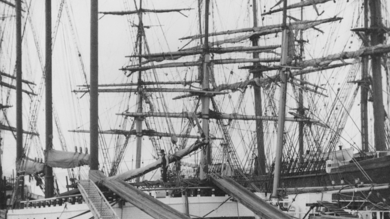
1895: Loading timber for export in Tacoma, Washington
The California Gold Rush, beginning in 1848, created a huge demand for lumber for the resulting building boom in San Francisco and nearby mining towns. Much of this was supplied by lumber mills around Puget Sound in Washington. An international market for Pacific Northwestern lumber developed after 1871, when one local sawmill began exporting to Peru by ship. The lumber in this photo is probably bound for an international destination, as most of the wood sold domestically at the time was transported by rail by this time.
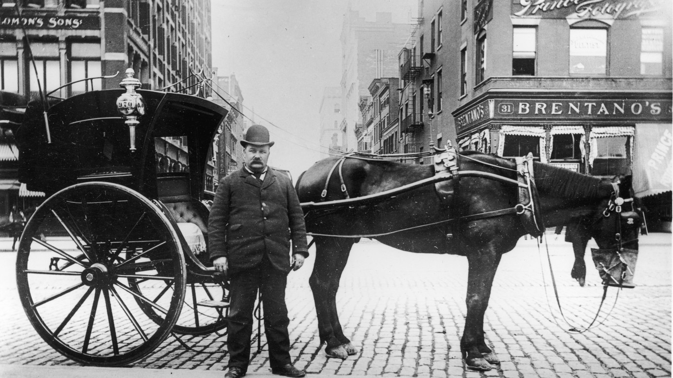
1896: A hansom cab on Union Square, New York City
The Hansom cab, patented in 1834, had an unusual design which placed the driver in an elevated box behind the passenger compartment. This image of a Hansom and its driver waiting for customers on Union Square in Manhattan was taken by Alice Austen, a noted photographer who first picked up a camera at the age of 10. She spent most of her professional career documenting life on Staten Island, where she lived.
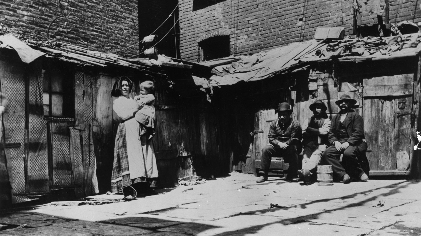
1897: Italian immigrants, Jersey Street, New York City
One of the many images of immigrant and tenement life in New York City taken by the Danish-American journalist, social activist, and photographer Jacob Riis in the late 19th and early 20th centuries, this is a group portrait of a family of Italian newcomers to America who lived in a shack on Jersey Street in the neighborhood now known as SoHo.
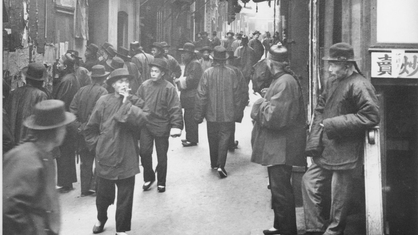
1898: A view of Chinatown, San Francisco
The German-American photographer Arnold Genthe, famous for his photographs of San Francisco, especially of Chinatown and of the aftermath of the 1906 earthquake that devastated the city, shot this picture on Ross Alley — Chinatown’s so-called “street of gamblers.” Running parallel to Stockton Street and Grant Avenue, the street was built in 1849, and soon became known for its brothels and gambling dens.